
| US Virgin Islands Prepares for Tsunami |
| 送交者: 2014年01月27日05:20:07 于 [世界军事论坛] 发送悄悄话 |
|
|
|
January 20, 2014 | 7:00 am | Print 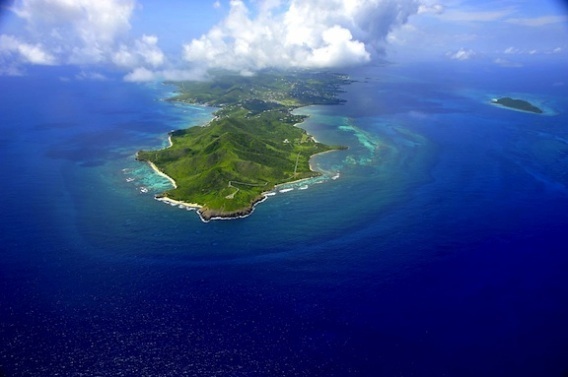 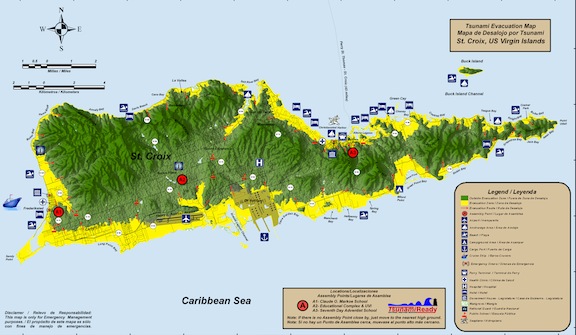 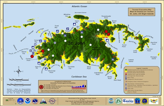 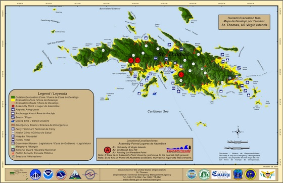  Above: the USVI By the Caribbean Journal staff As last week’s earthquake in Puerto Rico reminded, the Caribbean is a seismically active region — and particularly the northern Caribbean. That’s led the US Virgin Islands to debut its first-ever tsunami evacuation map, which covers St Croix, St john and St Thomas. The maps “delineate coastline inundation in the event of the Territory is impacted by a tsunami, as well as safe areas, evacuation route directional arrows, assembly points and denotes public schools and other public facilities within the inundation area,” according to a statement from the office of Governor John de Jongh.
Above: the St Croix evacuation map “VITEMA is proud to announce the availability of the Territory’s first Tsunami Evacuation Maps for the islands of St Croix, St John and St Thomas,” said Elton Lewis, director of the Virgin Islands Territorial Emergency Management Agency.
Above: the St Thomas evacuation map The maps were created with the help of an $18,000 grant from the National Oceanic and Atmospheric Administration.
Above: the St John evacuation map The territory will soon be launching a public education programme that will include town hall meetings and map distributions. VITEMA has also applied to the NOAA’s National Weather Service to be certified as a “TsunamiReady” community. “All of this effort led to building awareness of tsunamis,” de Jongh said. “Today we’ve laid the groundwork not only for our residents and businesses to be ready, but to be resilient.” |
|
|
|
|
 |
 |
| 实用资讯 | |
|
|
|
|
| 一周点击热帖 | 更多>> |
|
|
|
| 一周回复热帖 |
|
|
| 历史上的今天:回复热帖 |
| 2013: | 环球时报:朝鲜威胁第三次核试验 “以瞄 | |
| 2013: | 专家:核弹带不来朝鲜安全 朝勿增加中国 | |
| 2012: | 看来该城管出马了,日本驻华新大使馆原 | |
| 2012: | 安玛:建议胡温交接前该做的两件事 | |
| 2011: | 没想到陈老板的善举有这么大的冲击 | |
| 2011: | 冬日中的新舰-"常州"舰即将交 | |
| 2010: | 我是大汉族主义,主张本世纪把外蒙古收 | |
| 2010: | 同志们,史上最伟大的个人电脑出现了, | |
|
|